**Editor’s Note***
– High Bar FN has closed off High Bar Rd to non-indigenous persons about 2-3 years ago, I’m not sure if it is signed or not at the road itself. You may want to contact them for more information. 250-459-2117
_____________
Last November I endeavored on a multi-day solo excursion before winter set in here in the southern half of British Columbia. Ultimately I was looking to end up exploring around the Gang Ranch and Empire Valley area which is rich in history and jaw-dropping scenery. November can bring warm sunny days, but the nights are chilly, which allowed me to see cacti and fresh snow in the same day!
I left through the Fraser Valley at night, travelling driving an eerie fog.

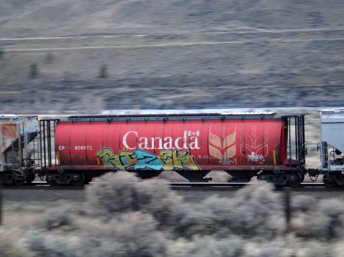
I continued north from Hope on Hwy 1 through the Fraser Canyon area, but I had an alternate route in mind. Rather than drive the paved highway which I’ve done numerous times, I saw a route on the backroads map book which connected the Boothroyd area to the Nicomen Indian Band community, just east of Lytton. It looked like a slower, less direct route over old logging roads, but it would satisfy my appetite for checking out new roads, at least for that evening.
I was listening to the US election results on CBC radio while climbing up the pitch black gravel roads in the pouring rain. The radio was reporting that Donald Trump was edging out Hillary Clinton in counted votes so far, however the official result was not yet known. Once out of radio reception (which doesn’t take look in mountainous B.C.), I observed a large orange glow in the night sky. This was extremely unusual as there were no houses, buildings or even power lines in this area.
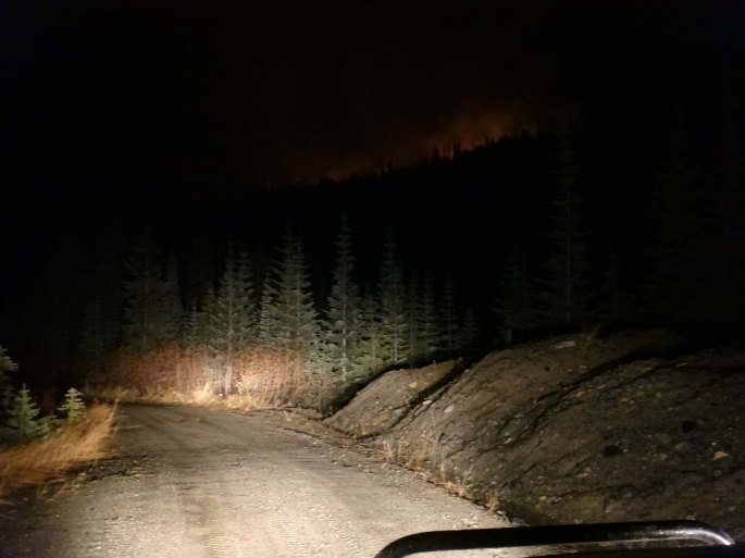
What made things more bizarre is that it was November – not exactly forest fire season. It was also still absolutely pouring rain and I doubted any wildfires would have started up out there. For a moment I surmised it could have been a large airplane crash, which was a horrible thought, up there on the wet and dark mountainside and all. I stopped to examine the map and found a way to drive up to the glow.
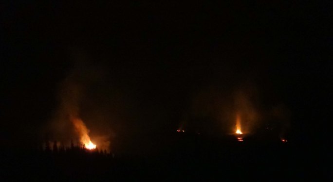
After climbing up a few hundred metres to the glow, I came to an area of clear cuts and numerous burning slash piles. Of course this was a more logical explanation… These were some major flames though – some over 40 feet in the air at least. I could even hear the fire crackling from half a kilometre away. Considering the current fire situation in B.C. (summer of 2017 – worst on record), burning these off on a rainy November night seems like a good idea.
With the burst of excitement over, I traced my path back to the intended route and setup camp in the back of the truck under Mount Lytton, and the headwaters of the Nicomen River. The rain was still falling generously and the wind shook the truck all night.
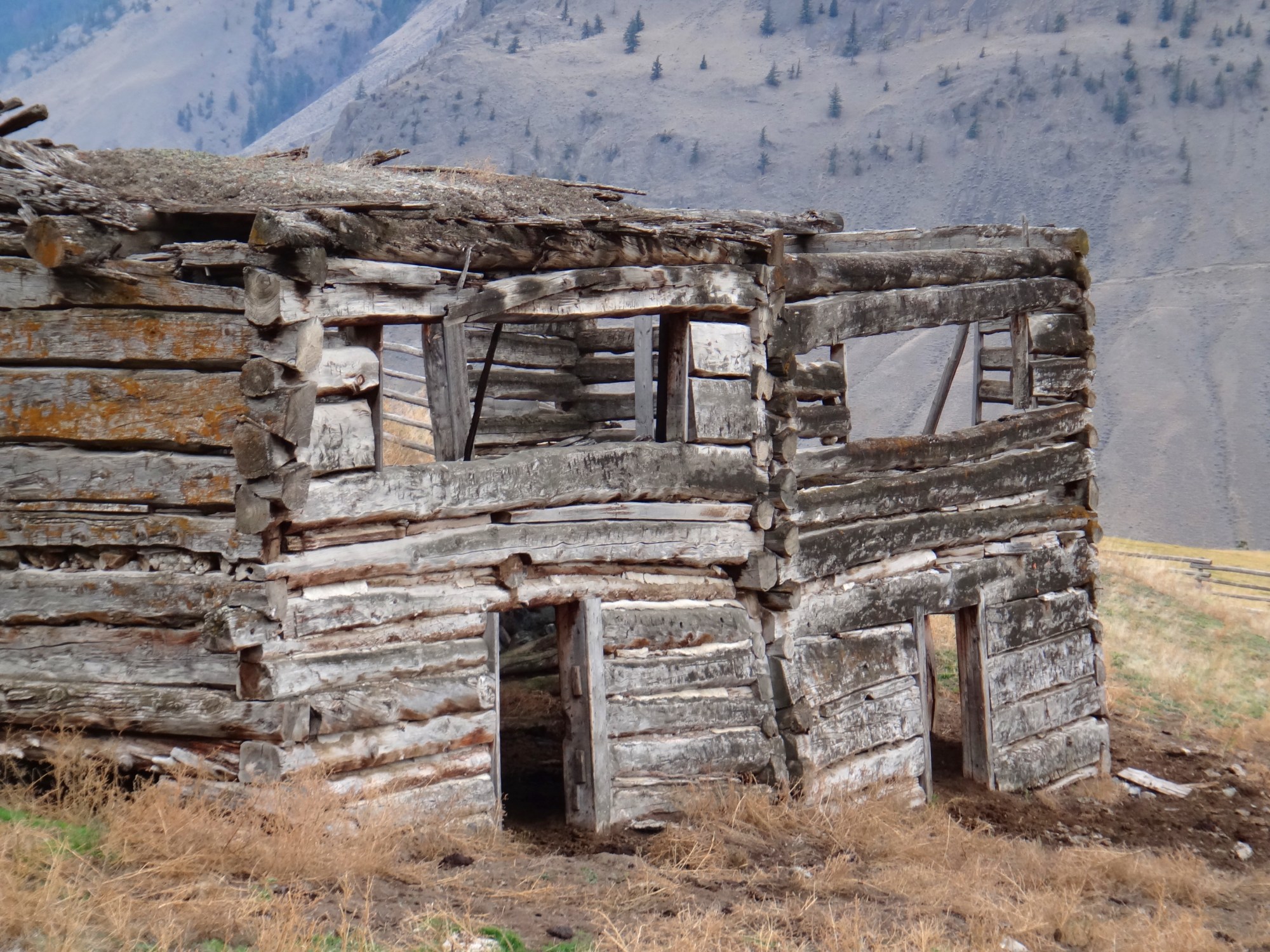
In the morning I continued north and came across this gem, rusting away like a forgotten tool left behind.

The Nicomen River was raging after all the rainfall overnight.

Sometime in the morning I stopped and hiked up above the Nicoamen community to check out the falls and more views of the canyon:


I stopped in Spences Bridge for lunch (the Packing House is always fresh), and although the bridge is gone (history repeating itself), the town still has some funk to it:


I crossed the river in Spences Bridge and continued up the valley on the east side. This is an unmaintained dirt road with gates requiring you to open and close as you go along.

The road curves and twists its way alongside the river, demanding the driver’s attention with steep hills and blind corners. Every once in awhile, a loud angry train whizzes past.
Following this road will bring you out to Basque and the Ashcroft area. For some reason, there were plenty of old classic cars abandoned along the route.


One of the most popular sights in this area is this old abandoned church, often viewed from across the river on the main highway. This was my first time seeing it up close, how fitting that it was getting dark and the wind was causing things inside to make classic old-abandoned-church (creepy) noises.

That evening I continued out to Clinton, then up the Kelly Lake Rd to the junction with the Jesmond Rd. Anyone who has seen this signpost in person will have felt the urge to explore all these back roads as the area has a certain historic feel to it. When you start to see more and more remnants of a life gone by – a much different life than we are all familiar with today – you’re left feeling like this is a special place. Seeing these types of sign posts makes pumped for these types of trips!

I setup the truck camp underneath the Marble Range between Clinton and the Fraser River. This is a unique looking set of mountains as the rock type is prominent and has a white-ish tinge to the hills. A recent fire in the area adds to the unusual views.

I unloaded the mountain bike and rode some of the deactivated roads carved out of the hillsides. I even spent a few hours hiking up one of the unnamed white peaks, topping out around 2100 metres (6900 ft). There was no trail and no sign of anyone previously having been up there – although I’m sure a few explore the area every year.


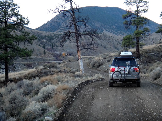
Returning to my bike, and eventually the ENDURANCE, I was off to explore desert country on the High Bar Rd.

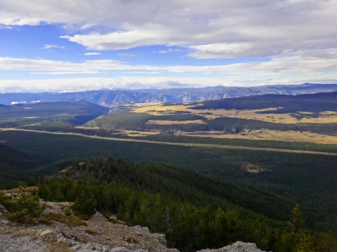
Before descending a few thousand feet down to the Fraser River, there is a lookout the locals call Cougar Point. This is a great spot to stop for lunch or to make a coffee and check out the vistas.

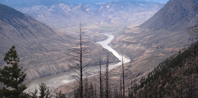
I utilized 4-low gearing for the descent down the hill. This is another stretch of road requiring all of the driver’s attention. I found myself stopping often to take in the views.

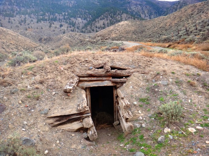
At the bottom, the road mellowed out and wound it’s way along the bench lands and picturesque private farms. Experiencing some of the structures was like travelling back in time.

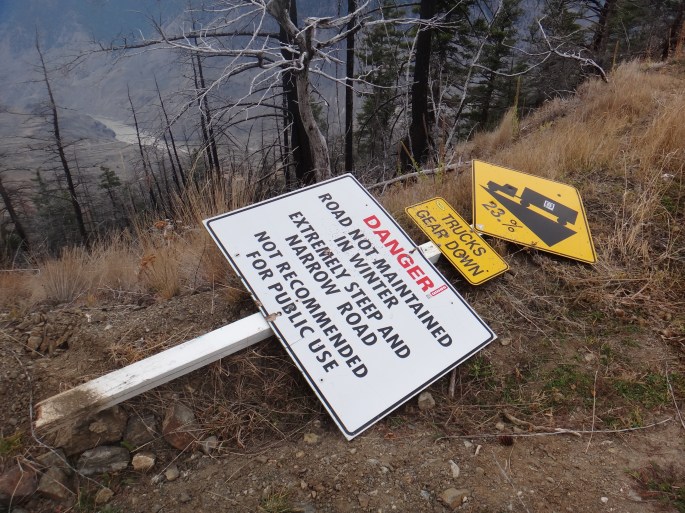
The following photos of the High Bar area include Black Canyon, Fraser River sand dunes, as well as hoodoos and a not-so-clever sign.


Prior to crossing the river to the Gang Ranch side, I dashed up to the high forests again to the Jesmond Road area and the Jesmond Fire Lookout. The road starts off in smooth 2wd condition, but once you start climbing you encounter water bars and rough uneven road surfaces. 4-low gearing, high clearance, and airing down the tires is recommended!
I reached the top after dark. The wind was furious and howling away all night. Up at just under 2000 metres elevation, the air temperature was hovering just below zero and with the wind chill factored in at 50-70 km/h gusts, I was glad I was camping in the truck! To top it all off, I was having issues with the trusty Coleman propane stove. The issues resulted in no hot food or coffee while over-nighting up at the lookout. The views in the morning made up for the lack of comfort food.
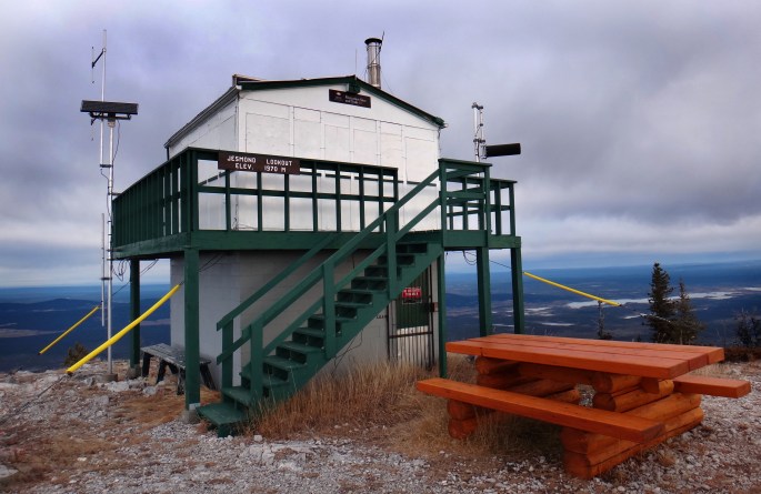
The stove issue turned out to be a faulty propane hose, and not a breakdown of the trusty Coleman camping staple. With a working stove and a new day ahead, I ran into town (100 Mile House) to restock on some goodies, and pointed the nose of the Sequoia back west toward Gang Ranch.
I spent another night bush camping near Gustafsen Lake, east of 100 Mile House. Gufstafsen Lake has a unique and unexpected history – a large standoff between Police/local ranchers and First Nations. Bullets were fired and a truck was even blown up – you’ll have to google it to read more!
I fueled up in Dog Creek, bought a coffee and had a friendly chat with a local running the general store. “Farming and logging” were the only things to do in the area jobwise he told me, except of course for running the local general store. I may have been his only non-local customer that day! Driving through the community I received waves from all the locals I passed, including one denim-clad First Nations farmer riding a tractor with two or three dogs running behind.

Finally, on the afternoon of the fourth day I reached the remote bridge that crosses the Fraser River and leads to Gang Ranch. A novel could be written on the history of this area, in fact there are probably several written and published out there somewhere. This place, along with the adjacent Churn Creek/Empire Valley, is one of those jewels of B.C. where anyone with an adventurous spirit should explore.
I spent the next few days scoping out the trails and camp spots, even some hairy four-wheeling up an icy road on Black Dome Mountain.


Between the history, unusual landscape, and diversity of flora and fauna, this place just feels special. Go check it out!
-JC.

Thanks so much! Lovely history lesson for a part of the country I have yet to explore!
LikeLike
Thank you for the tour, brought back memories. Been on the High Bar road many times to go see my sister, the root cellar looks like hers. The fire burned a lot of things but I heard it never burned the trees in the creek that we carved our initials in. The sign that says 23% grade and facing up, not down was the only sign the highway dept had with such a high grade on it so that was used. The grade was more than 23%!
I remember going down the road with lightning hitting all around and the water running down the road in a muddy, foamy stream behind us and my husband being told to drive faster because we had to outrun the water before it washed away the road in front of us.
LikeLike
Hi, we lived in Clinton, Kamloops area for many years. We had a great cabin on Meadow Lake for a few years. We’d take our horses there in the late spring. Our girls enjoyed ‘truckin” up to the Dude ranch at Beaver dam lake for “play days” with the young guests there. Traveled most of those roads. Had a great time in that country, winters and summers. We always stocked our cabin with lots of food as in winters one could get snowed in for a few days at a time. A great family are the Kosters who operate the B.C. Cattle Company ranch at Canoe Creek. Wonderful people.We now live in Merritt.
LikeLiked by 1 person
My god 23 percent grade? That is a bit extreme. 🙂 Good reason for low-range gearing and hill decent control. I really enjoyed the photos! We’re considering an adventure into British Columbia sometime in the next few years. Any books you can recommend on the region?
LikeLike
I’m sure there are many. Any visitor centre should have a good variety.
LikeLiked by 1 person
I’m looking forward to replicating this route in 2022
LikeLike
Hi all. High Bar FN has reached out to let everyone know that the public is no longer welcome on High Bar Rd.
LikeLike