The website is pretty new and most of the work has been going on behind the scene, including trip reports, work on the vehicles and actually getting some trips in. I’ll be uploading more content soon – so far XpedBC hasn’t really been advertised or posted about much!
In November years ago, I made a trip down to Solcum Creek campground on the southern end of the Owhyee Resivor where I planned to set it with my kayak. Prior to that day, I camped at Leslie Gultch. The weather was warm with Blue skies. The following morning, two ranch kids stopped in and warned of the potential of rapid weather changes. Later that afternoon I made it down to the Solcum campground. I unloaded my kayak anticipating an early launch in the morning. I spent the night inside the canopy of my Toyota pickup. When I awoke the following morning, snow was dumping. I quickly loaded my boat and headed up the curvey 7 mile grade to the main road. The snow accumulated rapidly as I drove on. Visibility was slim. When I finally got to the main road, I turned left at the “t” and headed towards Adrian (black top). The falling snow was heavy, I had to stick my head out the window and watched the gravel road’s edge to maintain staying on the road all the way to Adrian. Awesome experience! Made it back 20yrs later and launched my kayak for a 3 day outting. Camped at the remote Owhyee gravel runway. Incredible red rock views and a huge herd of mountain sheep. Oh, and the weather was fantastic!!
Nice meeting you at the NWOR this week, maybe we’ll meet up again for some BC fun this summer, I told you about the Vancouver island trip I will take in July. Let me know if you want to join up.
Thanks Noel – it was cool to see another Sequoia getting properly used out there! Keep us in the loop of the Island trip, that is an area we want to see more of for sure. Check out http://www.Sequoia-Forums.com – there is a Sequoia Summit in Colorado coming up next year.
Just curious what access you are using for the Shulaps range? I’m hoping to do a bit of hiking in there this summer, but prefer to access the area from the East side, rather than going over to the Marshall lake side.
I used the forest road that leaves Hwy 40 just west of the Moha and Yalakom Rd Junction. This was on the east side of the range. From that point there are a number of roads zigzagging around the Shulaps area. There are possibly some new motorized restrictions in the alpine area so make sure to keep an eye out for signs while accessing your hikes!
We enjoyed being your camping neighbour and the chats. Hoping you have a blast up in the Yukon and Alaska and please let us know if you end up documenting the trip somewhere!
I was intrigued by your setup when I noticed it in Princeton! Whole family gathered up and off to the next adventure. I just want to say you are a great ambassador for the 4 Wheeling community and took the time to talk about the hobby! It really inspired me and the boys to “get busy wheeling” again! Would love to join you on some of the adventures and perhaps entice you to a few wheeling ops here under the Slocan Ridge.
Craig! It was good to meet you – we’re always happy to chat with other adventurers on our travels. We ended up having a rad time in the Kootenays, from good camp spots, to some pretty insane high alpine roads we found! The Kicking Horse Coffee is wicked too.
When you come down off of the last big push up to the lookout there is a small campsite on your right called Three Sisters, come down a little further and take the road to the right (driveable all year), it brings you out in what is called Lower Hat and after a few beautiful farms and stuff you pop out on Highway 99 so you get to return to the coast on 99 if you wish or turn right and regain Hiway 97 North, passing Hat Creek Heritage House. I have many times nearly frozen in the cold wind at the Ashcroft Lookout, love your web site and your trips, I do have an old 4x Kia and if I don’t get any older than the 80 that I currently am, I just might join you on an adventure, but summer please.
My name is Bryan Oliveira and I am the GM for Freespirit Recreation in Bend Oregon. The last week of July I have some business with Cap-IT to address. Afterwords I am looking to have an adventure for a week with my family in my 1993 rover and my sons Jeep. I was hoping that you could give some great advice on where to go for some epic scenery! I noticed that you were at the NW Overland rally last year in Plain, WA. Will you be there again? I will be there in FSR’s booth and I would love the opportunity to talk with you if so. Thanks in advance for your assistance. Look forward to hearing from you.
Hey Brian, thanks for contacting us! We’d love to help you out with some suggestions, and we will be at the NWOR all weekend. I’ll try and swing by your booth, but if we don’t meet up, shoot us a message on our facebook page and we can go from there! -JC
Hi, I found your site on google when looking for info and the accessibility of the Ashnola -Placer Mtn. connection. We are on dual sport bikes looking to get off the pavement on our way to Nighthawk to begin the WABDR.
I could not see any dates on your trip log and want to inquire as to the date of your report? Additionally, since I have never explored the area BRMB shows a variety of Placer Mtn FSR “loops” that might connect through to Ashnola Road. We are looking to travel west to east. Do you have any advice on which routes work or don’t? Do you have any GPX logs or any intel on wether dual sport bikes would get through?
Many thanks
Hi David, sorry for the late reply – we’ve been out on a trip for the past two weeks, partly on the WABDR!. Our trip over the Ashnola-Placer traverse occurred about 13 months ago. I haven’t been back to the area since the report was made, but at the time it should be easily ridden on a loaded dual sport. The only somewhat tricky sections would be the steep/tight switchbacks, but I don’t think it would be any real trouble. Unfortunately I don’t have any logs to show for the area, as we typically rely on the Backroad Mapbook paper maps. From what I know, there is only one road that actually connects up high. If you are still having trouble, I could screenshot the way through if you’d like.
I really enjoyed your website and all the insite full comments. We have just come back from a trip up the Dempster Highway and the road to Tuktoyaktuk and the Arctic Ocean. Like you guys we use the Back roads maps. Paper is very reliable when there is no internet. will check in ocassionally here. thank you!
Hey, Im planning a trip from Revelstoke through to Pemberton using only logging roads and trails and was wondering if you know of anyway through from the Gang Ranch area to Gold Bridge?
Hi Chris – sorry for the delayed response. Your best bet from Gang Ranch south to Gold Bridge is along the Fraser River. You can cross the bridge near Gang Ranch to the east side near Dog Creek, then cross back to the west side at the Big Bar reaction ferry. From there, you have an option of following the river down the West Pavillion Rd, or take the Big Bar-China Head traverse which is a 4×4 high clearance only route over to the Yalakom FSR. At that point you can take the Mud Lakes FSR south to Gold Bridge, or follow the Yalakom FSR back to Hwy 40 and take that to Gold Bridge. On the backroad mapbook there appears to be roads connecting from the back of Gang Ranch (Gaspard FSR? Yodel Camp Rd?) out to the Mud Lakes FSR area but I’m not sure if they are passable. Hope this helps!
Hi, I appreciate the details of your adventures, and its of interest to me. Read about your Cooper tire review and you mentioned that you run with a disconnected front sway bar full time….. in the city does that not give really poor handling when taking corners? I’ve read of sway bar disconnects, but not permanent disconnection. And what other vehicles did you consider before buying the Sequoia? (perhaps the runner up and 3rd place). Thanks. Dave (Abbotsford)
You can feel the difference in handling around town and on the twisty highways, however for us the Sequoia is modified for a specific purpose. We are happy with the decrease in higher speed stability as we simply do not drive aggressively around town or on the highways.
As for other vehicles… an 80 or 100 series Land Cruiser was always high on the list. We owned two 4-runners, including an solid-axle-swapped one, prior to the Sequoia. We made the jump up in size as the family grew.

Why is there only one post on here?
LikeLike
Hi James,
The website is pretty new and most of the work has been going on behind the scene, including trip reports, work on the vehicles and actually getting some trips in. I’ll be uploading more content soon – so far XpedBC hasn’t really been advertised or posted about much!
LikeLike
In November years ago, I made a trip down to Solcum Creek campground on the southern end of the Owhyee Resivor where I planned to set it with my kayak. Prior to that day, I camped at Leslie Gultch. The weather was warm with Blue skies. The following morning, two ranch kids stopped in and warned of the potential of rapid weather changes. Later that afternoon I made it down to the Solcum campground. I unloaded my kayak anticipating an early launch in the morning. I spent the night inside the canopy of my Toyota pickup. When I awoke the following morning, snow was dumping. I quickly loaded my boat and headed up the curvey 7 mile grade to the main road. The snow accumulated rapidly as I drove on. Visibility was slim. When I finally got to the main road, I turned left at the “t” and headed towards Adrian (black top). The falling snow was heavy, I had to stick my head out the window and watched the gravel road’s edge to maintain staying on the road all the way to Adrian. Awesome experience! Made it back 20yrs later and launched my kayak for a 3 day outting. Camped at the remote Owhyee gravel runway. Incredible red rock views and a huge herd of mountain sheep. Oh, and the weather was fantastic!!
LikeLike
Nice meeting you at the NWOR this week, maybe we’ll meet up again for some BC fun this summer, I told you about the Vancouver island trip I will take in July. Let me know if you want to join up.
N. Aka big Tree
LikeLike
Thanks Noel – it was cool to see another Sequoia getting properly used out there! Keep us in the loop of the Island trip, that is an area we want to see more of for sure. Check out http://www.Sequoia-Forums.com – there is a Sequoia Summit in Colorado coming up next year.
LikeLike
Just curious what access you are using for the Shulaps range? I’m hoping to do a bit of hiking in there this summer, but prefer to access the area from the East side, rather than going over to the Marshall lake side.
LikeLike
I used the forest road that leaves Hwy 40 just west of the Moha and Yalakom Rd Junction. This was on the east side of the range. From that point there are a number of roads zigzagging around the Shulaps area. There are possibly some new motorized restrictions in the alpine area so make sure to keep an eye out for signs while accessing your hikes!
LikeLike
It was great meeting you and your family at the Overland Rallies. Keep in touch, Justin (Tan Van)
LikeLike
We enjoyed being your camping neighbour and the chats. Hoping you have a blast up in the Yukon and Alaska and please let us know if you end up documenting the trip somewhere!
LikeLike
I was intrigued by your setup when I noticed it in Princeton! Whole family gathered up and off to the next adventure. I just want to say you are a great ambassador for the 4 Wheeling community and took the time to talk about the hobby! It really inspired me and the boys to “get busy wheeling” again! Would love to join you on some of the adventures and perhaps entice you to a few wheeling ops here under the Slocan Ridge.
LikeLike
Craig! It was good to meet you – we’re always happy to chat with other adventurers on our travels. We ended up having a rad time in the Kootenays, from good camp spots, to some pretty insane high alpine roads we found! The Kicking Horse Coffee is wicked too.
LikeLike
When you come down off of the last big push up to the lookout there is a small campsite on your right called Three Sisters, come down a little further and take the road to the right (driveable all year), it brings you out in what is called Lower Hat and after a few beautiful farms and stuff you pop out on Highway 99 so you get to return to the coast on 99 if you wish or turn right and regain Hiway 97 North, passing Hat Creek Heritage House. I have many times nearly frozen in the cold wind at the Ashcroft Lookout, love your web site and your trips, I do have an old 4x Kia and if I don’t get any older than the 80 that I currently am, I just might join you on an adventure, but summer please.
LikeLike
My name is Bryan Oliveira and I am the GM for Freespirit Recreation in Bend Oregon. The last week of July I have some business with Cap-IT to address. Afterwords I am looking to have an adventure for a week with my family in my 1993 rover and my sons Jeep. I was hoping that you could give some great advice on where to go for some epic scenery! I noticed that you were at the NW Overland rally last year in Plain, WA. Will you be there again? I will be there in FSR’s booth and I would love the opportunity to talk with you if so. Thanks in advance for your assistance. Look forward to hearing from you.
LikeLike
Hey Brian, thanks for contacting us! We’d love to help you out with some suggestions, and we will be at the NWOR all weekend. I’ll try and swing by your booth, but if we don’t meet up, shoot us a message on our facebook page and we can go from there! -JC
LikeLike
Hey Bryan, it was good meeting you at the NWOR. Be sure to send us a facebook message and we’ll work out a nice list of places to see when in BC!
LikeLike
Hi, I found your site on google when looking for info and the accessibility of the Ashnola -Placer Mtn. connection. We are on dual sport bikes looking to get off the pavement on our way to Nighthawk to begin the WABDR.
I could not see any dates on your trip log and want to inquire as to the date of your report? Additionally, since I have never explored the area BRMB shows a variety of Placer Mtn FSR “loops” that might connect through to Ashnola Road. We are looking to travel west to east. Do you have any advice on which routes work or don’t? Do you have any GPX logs or any intel on wether dual sport bikes would get through?
Many thanks
LikeLike
Hi David, sorry for the late reply – we’ve been out on a trip for the past two weeks, partly on the WABDR!. Our trip over the Ashnola-Placer traverse occurred about 13 months ago. I haven’t been back to the area since the report was made, but at the time it should be easily ridden on a loaded dual sport. The only somewhat tricky sections would be the steep/tight switchbacks, but I don’t think it would be any real trouble. Unfortunately I don’t have any logs to show for the area, as we typically rely on the Backroad Mapbook paper maps. From what I know, there is only one road that actually connects up high. If you are still having trouble, I could screenshot the way through if you’d like.
LikeLike
Hello
I really enjoyed your website and all the insite full comments. We have just come back from a trip up the Dempster Highway and the road to Tuktoyaktuk and the Arctic Ocean. Like you guys we use the Back roads maps. Paper is very reliable when there is no internet. will check in ocassionally here. thank you!
LikeLike
Hey, Im planning a trip from Revelstoke through to Pemberton using only logging roads and trails and was wondering if you know of anyway through from the Gang Ranch area to Gold Bridge?
LikeLike
Hi Chris – sorry for the delayed response. Your best bet from Gang Ranch south to Gold Bridge is along the Fraser River. You can cross the bridge near Gang Ranch to the east side near Dog Creek, then cross back to the west side at the Big Bar reaction ferry. From there, you have an option of following the river down the West Pavillion Rd, or take the Big Bar-China Head traverse which is a 4×4 high clearance only route over to the Yalakom FSR. At that point you can take the Mud Lakes FSR south to Gold Bridge, or follow the Yalakom FSR back to Hwy 40 and take that to Gold Bridge. On the backroad mapbook there appears to be roads connecting from the back of Gang Ranch (Gaspard FSR? Yodel Camp Rd?) out to the Mud Lakes FSR area but I’m not sure if they are passable. Hope this helps!
LikeLike
I know this post is old, BUT, are you able to send me some info on the route you took and also does this FSR turn into Placer Lake?
LikeLike
Hi Kim, we just followed the bc backroad mapbooks, paper version!
LikeLike
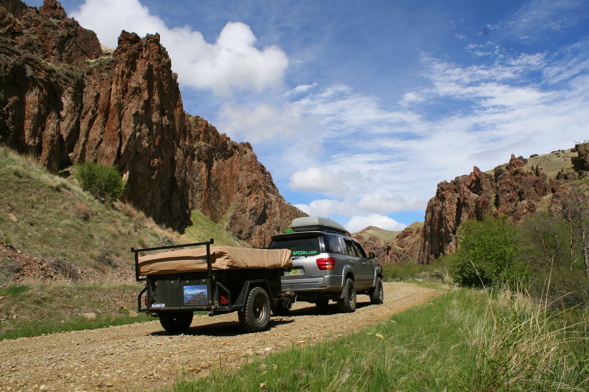
Great site! I ran a bushranger trailer but am now using a RTT. The trailer was great for us when all 3 or 4 kids were along for the trip.
LikeLike
Hi, I appreciate the details of your adventures, and its of interest to me. Read about your Cooper tire review and you mentioned that you run with a disconnected front sway bar full time….. in the city does that not give really poor handling when taking corners? I’ve read of sway bar disconnects, but not permanent disconnection. And what other vehicles did you consider before buying the Sequoia? (perhaps the runner up and 3rd place). Thanks. Dave (Abbotsford)
LikeLike
Hey Dave,
You can feel the difference in handling around town and on the twisty highways, however for us the Sequoia is modified for a specific purpose. We are happy with the decrease in higher speed stability as we simply do not drive aggressively around town or on the highways.
As for other vehicles… an 80 or 100 series Land Cruiser was always high on the list. We owned two 4-runners, including an solid-axle-swapped one, prior to the Sequoia. We made the jump up in size as the family grew.
Glad you are enjoying the trip reports. JC
LikeLike
Hey everyone, I am new to the area and was looking for some longer multiday overland adventures, does anybody have an recommendations or maps?
LikeLike
Where is your home base Max?
LikeLike